Species Distribution
Overview
Our main question is how to calculate the distribution of a species and what factors determine it. We do this by a variety of methods that include niche modeling, remote sensing, and population ecology modeling.
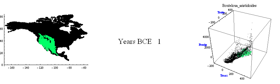
Image above: The figure has a map of North America, gridded, and a three dimensional scatterplot, in which each data point corresponds to a cell in the map of North America. Climate is changing in the scatterplot, as calculated by a General Circulation Model. As it changes, climate combinations enter or leave an ovoid shape (constant in size and position) representing the niche of a species. If a climate combination moves inside the niche (the ovoid) it is highlighted in the map as suitable for the species. Therefore, as climate changes in the scatterplot, a suitable region changes position in the map. This is an animated representation of how climate drives changes in an area of distribution.
Understanding Areas of Distribution

Image above: The equation represents the rate of change of population size, for a species, in any cell in a geographic grid. There are three terms for this change. The first one is the intrinsic rate of growth, affected mainly by climate, topography, or other non-interactive factors. The second term is the interactive contribution of resources, competitors, predators and mutualists. The third term is the contribution of emigration from the grid cell (negative) and immigration to the grid cell (positive).
Areas of distribution are the results of several processes like dispersal, physiological tolerances, interactions with other species, habitat preferences, and evolution. Our approach is based on a mechanistic understanding of these processes: how they are likely to affect the presence of a species in some place, and how they change.
See Soberón, J. Niche and area of distribution modeling: a population ecology perspective. Ecography 33, 159-167 (2010). Read more about biodiversity patterns.
Image above: An animated map of central United States, Mexico and Central America, where an invasive species starts in Florida and spreads over areas suitable in climate and accessible to dispersion. The animation shows how, starting in Florida, the Ambrosia bark beetle (a pest of avocados) spreads westwards and southwards, finally invading Mexico and parts of Central America.
Dynamic Modeling
One of the frontier areas in modeling distributions is to add dynamical behavior to the models. This can be done in at least three ways, first, as above, by using time varying parameters in a niche model. Second, by modeling the population dynamics in a coupled lattice of localities. This is theoretically very satisfactory, but numerically quite demanding. And finally, using a cell automaton approach, where one models the “contagion” of occupied cells by others. This last approach has been modeled in collaboration with Dr. Luis Osorio, of the Instituto de Ecologia, in Mexico. Below there is an animation of such model, for the introduced pest of avocados, Xyleborus glabratus.
Use of Niche Models in Invasive Species Risk Assessment
In the book Ecological Niches and Geographic Distributions (Peterson et al, 2011, Princeton University Press) our research has develop this theme, showing how extremely useful niche modeling can be to transfer predictions in space.
Our working group has studied invasions by insects, mostly the Cactus moth and the Ambrosia bark beetle but we participate in the policy decisions on invasive species mostly advising the Government of Mexico.