Missouri River Basin
Oahe Dam was constructed over the Missouri River from 1948 to 1959. The resulting reservoir is the 4th largest artificial lake in the United States, stretching 231 miles from just north of Pierre, South Dakota to Bismarck, North Dakota. As a result of the dam’s construction, prime agricultural and forested lands were inundated, the Cheyenne River Indian Reservation and the Standing Rock Sioux Reservation lost thousands of acres and the associated traditions and economies, and hundreds of prehistoric and historic archaeological sites were destroyed.
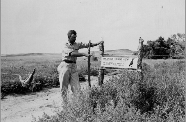
Under agreements between the University of Kansas and the National Park Service, and in cooperation with the Smithsonian Institution River Basin Surveys, Carlyle Smith directed field investigations at the Talking Crow site (39BF3) in the summers of 1950, 1951 and 1952. Talking Crow was one site impacted by the construction of the Oahe Lake. Smith also conducted investigations at other sites within the Missouri River Basin, including the Spain site (39LM301) in 1953, the Two Teeth (39BF204) and Cadotte (39HE202) sites in 1955, and the Stricker (39LM1) site in 1959.
View Archaeology Missouri River Basin Image Album (Flickr)
Missouri River Basin Collection
| SITE | SITE NAME | YEAR OF INVESTIGATION | COLLECTION SIZE |
|---|---|---|---|
| 39BF3 | Talking Crow | 1950-1952 | 109ft³ |
| 39BF204 | Two Teeth | 1955 | 26ft³ |
| 39LM1 | Stricker | 1959 | 12ft³ |
| 39LM47 | Clarkstown | 1953 | 2ft³ |
| 39LM2 | Medicine Creek | 1953 | 1ft³ |
| 39HE202 | Cadotte | 1955 | 3ft³ |
| 39LM301 | Spain | 1953 | 15ft³ |
| 39BF237 | Fire Cloud | 1955 | 1ft³ |
| 39LM33 | Dinehart Village | 1953 | 1ft³ |